Related
Jul 11,2011
Change Through Opt-in: Property Tax Reform in Bangalore

Oct 22,2009
The map below, from the Lincoln Institute’s Atlas of Urban Expansion (in print and online), shows the urban expansion of Cairo, Egypt from 1800-2000. According to UP scholar Solly Angel, Cairo’s growth offers valuable lessons about the need to come to terms with urban expansion in the developing world.
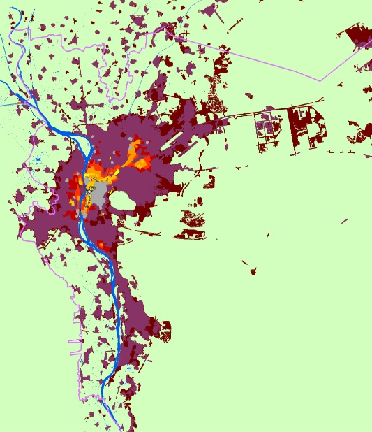

Despite Egypt’s official efforts to restrict the growth of Cairo to non-agricultural land, the the city began fanning out into the fertile Nile River delta after World War II. This expansion of informal settlements stemmed largely from bad housing policies that left people with few other options. Egyptian officials tried to limit development to new and rigidly planned towns outside of the city, but the new construction there fell wildly short of the growing demand for housing. Cairo’s rent control laws made the housing shortage even worse.
Sensing an opportunity, landowners in the fertile regions next to the city began skirting government restrictions—selling subdivided plots to private developers who built mixed-use multi-family structures, structures that were more accessible and affordable than those in the planned towns. By the late 1990s, informal areas hosted roughly 60 percent of greater Cairo’s residents.
Solly points out that the lack of public sector involvement in Cairo’s urbanization process likely reduced the amount of land allocated to public works, such as public space for parks or the arterial roads that carry public transit. Had Egypt come to terms with Cairo’s expansion earlier on, it might have facilitated urban expansion that was more effective, affordable, and sustainable.
Please fill out the information below to receive our e-newsletter(s).
*Indicates required.